Popular Destination
Sri Lanka is rich with various destinations and more things to do. In our Tour Packages we add many destinations to make your holiday unforgettable.
1.Anuradhapura
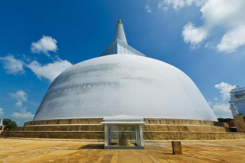
Anuradhapura is a major city in Sri Lanka. It is the capital city of North Central Province, Sri Lanka and the capital of Anuradhapura District. Anuradhapura is one of the ancient capitals of Sri Lanka, famous for its well-preserved ruins of an ancient Sinhala civilization. It was the third capital of the kingdom of Rajarata , following the kingdoms of Tambapanni and Upatissa Nuwara.
The city, now a World Heritage site, was the centre of Theravada Buddhism for many centuries. The city lies 205 km (127 mi) north of the current capital of Colombo in the North Central Province, on the banks of the historic Malvathu River. It is one of the oldest continuously inhabited cities in the world and one of the eight World Heritage Sites of Sri Lanka.
2.Polonnaruwa
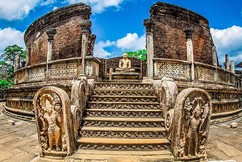
Poḷonnaruwa is the main town of Polonnaruwa District in North Central Province, Sri Lanka. Kaduruwela area is the Polonnaruwa New Town and the other part of Polonnaruwa remains as the royal ancient city of the Kingdom of Polonnaruwa.
The second most ancient of Sri Lanka’s kingdoms, Polonnaruwa was first established by the Chola dynasty after their successful invasion of the country’s then capital, Anuradhapura, in the 10th century. The Ancient City of Polonnaruwa has been declared a World Heritage Site.
1.Anuradhapura
Anuradhapura is a major city in Sri Lanka. It is the capital city of North Central Province, Sri Lanka and the capital of Anuradhapura District. Anuradhapura is one of the ancient capitals of Sri Lanka, famous for its well-preserved ruins of an ancient Sinhala civilization. It was the third capital of the kingdom of Rajarata , following the kingdoms of Tambapanni and Upatissa Nuwara.
The city, now a World Heritage site, was the centre of Theravada Buddhism for many centuries. The city lies 205 km (127 mi) north of the current capital of Colombo in the North Central Province, on the banks of the historic Malvathu River. It is one of the oldest continuously inhabited cities in the world and one of the eight World Heritage Sites of Sri Lanka.
2.Polonnaruwa
Poḷonnaruwa is the main town of Polonnaruwa District in North Central Province, Sri Lanka. Kaduruwela area is the Polonnaruwa New Town and the other part of Polonnaruwa remains as the royal ancient city of the Kingdom of Polonnaruwa.
The second most ancient of Sri Lanka’s kingdoms, Polonnaruwa was first established by the Chola dynasty after their successful invasion of the country’s then capital, Anuradhapura, in the 10th century. The Ancient City of Polonnaruwa has been declared a World Heritage Site.
3.Sigiriya Rock Fortress
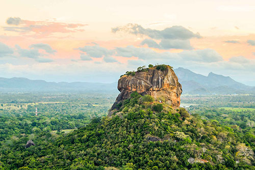
Sigiriya or Sinhagiri is an ancient rock fortress located in the northern Matale District near the town of Dambulla in the Central Province, Sri Lanka. The name refers to a site of historical and archaeological significance that is dominated by a massive column of rock around 180 metres (590 ft) high.
According to the ancient Sri Lankan chronicle the Culavamsa , this site was selected by King Kashyapa (477 – 495 AD) for his new capital. He built his palace on the top of this rock and decorated its sides with colourful frescoes. On a small plateau about halfway up the side of this rock he built a gateway in the form of an enormous lion. The name of this place is derived from this structure — Sīnhāgiri, the Lion Rock (an etymology similar to Sinhapura, the Sanskrit name of Singapore, the Lion City).
4.Dambulla Cave Temple
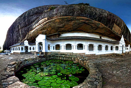
Dambulla cave temple also known as the Golden Temple of Dambulla is a World Heritage Site (1991) in Sri Lanka, situated in the central part of the country. This site is situated 148 kilometres (92 mi) east of Colombo , 72 kilometres (45 mi) north of Kandy and 43 km (27 mi) north of Matale .
Dambulla is the largest and best-preserved cave temple complex in Sri Lanka. The rock towers 160 m over the surrounding plains. There are more than 80 documented caves in the surrounding area. Major attractions are spread over five caves, which contain statues and paintings. These paintings and statues are related to Gautama Buddha and his life. There are a total of 153 Buddha statues, three statues of Sri Lankan kings and four statues of gods and goddesses. The latter include Vishnu and the Ganesha . The murals cover an area of 2,100 square metres (23,000 sq ft). Depictions on the walls of the caves include the temptation by the demon Mara, and Buddha's first sermon.
3.Sigiriya Rock Fortress
Sigiriya or Sinhagiri is an ancient rock fortress located in the northern Matale District near the town of Dambulla in the Central Province, Sri Lanka. The name refers to a site of historical and archaeological significance that is dominated by a massive column of rock around 180 metres (590 ft) high.
According to the ancient Sri Lankan chronicle the Culavamsa , this site was selected by King Kashyapa (477 – 495 AD) for his new capital. He built his palace on the top of this rock and decorated its sides with colourful frescoes. On a small plateau about halfway up the side of this rock he built a gateway in the form of an enormous lion. The name of this place is derived from this structure — Sīnhāgiri, the Lion Rock (an etymology similar to Sinhapura, the Sanskrit name of Singapore, the Lion City).
4.Dambulla Cave Temple
Dambulla cave temple also known as the Golden Temple of Dambulla is a World Heritage Site (1991) in Sri Lanka, situated in the central part of the country. This site is situated 148 kilometres (92 mi) east of Colombo , 72 kilometres (45 mi) north of Kandy and 43 km (27 mi) north of Matale .
Dambulla is the largest and best-preserved cave temple complex in Sri Lanka. The rock towers 160 m over the surrounding plains. There are more than 80 documented caves in the surrounding area. Major attractions are spread over five caves, which contain statues and paintings. These paintings and statues are related to Gautama Buddha and his life. There are a total of 153 Buddha statues, three statues of Sri Lankan kings and four statues of gods and goddesses. The latter include Vishnu and the Ganesha . The murals cover an area of 2,100 square metres (23,000 sq ft). Depictions on the walls of the caves include the temptation by the demon Mara, and Buddha's first sermon.
5.Yala National Park
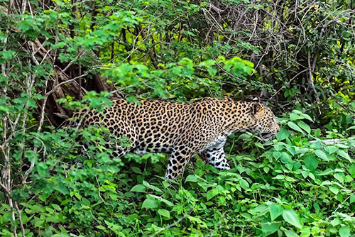
Yala National Park is the most visited and second largest national park in Sri Lanka, bordering the Indian Ocean. The park consists of five blocks, two of which are now open to the public, and also adjoining parks. The blocks have individual names such as, Ruhuna National Park (Block 1), and Kumana National Park or ‘Yala East’ for the adjoining area. It is situated in the southeast region of the country, and lies in Southern Province and Uva Province . The park covers 979 square kilometres (378 sq mi) and is located about 300 kilometres (190 mi) from Colombo. Yala was designated as a wildlife sanctuary in 1900, and, along with Wilpattu was one of the first two national parks in Sri Lanka, having been designated in 1938. The park is best known for its variety of wild animals. It is important for the conservation of Sri Lankan elephants, Sri Lankan leopards and aquatic birds.
6.Minneriya National Park
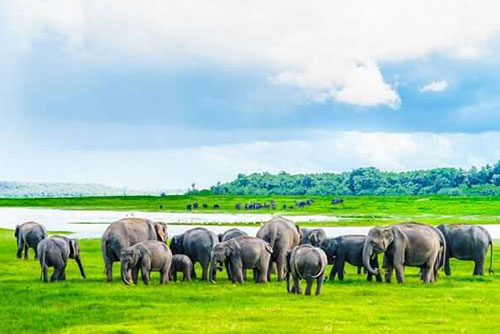
Minneriya National Park is a national park in North Central Province of Sri Lanka. The area was designated as a national park on 12 August 1997, having been originally declared as a wildlife sanctuary in 1938. The reason for declaring the area as protected is to protect the catchment of Minneriya tank and the wildlife of the surrounding area. The tank is of historical importance, having been built by King Mahasen in third century AD. The park is a dry season feeding ground for the elephant population dwelling in forests of Matale , Polonnaruwa , and Trincomalee districts. The park earned revenue of Rs. 10.7 million in the six months ending in August 2009. Along with Kaudulla and Girithale, Minneriya forms one of the 70 Important Bird Areas (IBAs) of Sri Lanka. The park is situated 182 kilometres (113 mi) from Colombo.
5.Yala National Park
Yala National Park is the most visited and second largest national park in Sri Lanka, bordering the Indian Ocean. The park consists of five blocks, two of which are now open to the public, and also adjoining parks. The blocks have individual names such as, Ruhuna National Park (Block 1), and Kumana National Park or ‘Yala East’ for the adjoining area. It is situated in the southeast region of the country, and lies in Southern Province and Uva Province . The park covers 979 square kilometres (378 sq mi) and is located about 300 kilometres (190 mi) from Colombo. Yala was designated as a wildlife sanctuary in 1900, and, along with Wilpattu was one of the first two national parks in Sri Lanka, having been designated in 1938. The park is best known for its variety of wild animals. It is important for the conservation of Sri Lankan elephants, Sri Lankan leopards and aquatic birds.
6.Minneriya National Park
Minneriya National Park is a national park in North Central Province of Sri Lanka. The area was designated as a national park on 12 August 1997, having been originally declared as a wildlife sanctuary in 1938. The reason for declaring the area as protected is to protect the catchment of Minneriya tank and the wildlife of the surrounding area. The tank is of historical importance, having been built by King Mahasen in third century AD. The park is a dry season feeding ground for the elephant population dwelling in forests of Matale , Polonnaruwa , and Trincomalee districts. The park earned revenue of Rs. 10.7 million in the six months ending in August 2009. Along with Kaudulla and Girithale, Minneriya forms one of the 70 Important Bird Areas (IBAs) of Sri Lanka. The park is situated 182 kilometres (113 mi) from Colombo.
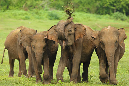
7.Pinnawala Elephant Orphanage
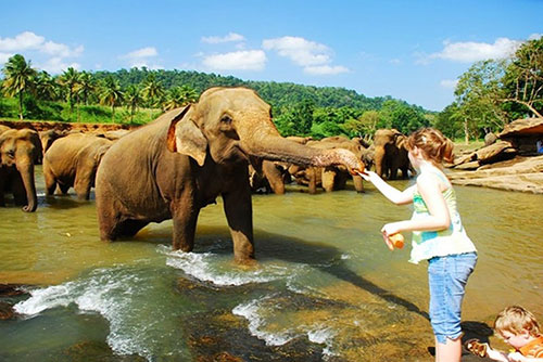
Pinnawala Elephant Orphanage is an orphanage, nursery and captive breeding ground for wild Asian elephants located at Pinnawala village, 13 km (8.1 mi) northeast of Kegalle town in Sabaragamuwa Province of Sri Lanka. Pinnawala has the largest herd of captive elephants in the world. In 2011, there were 96 elephants, including 43 males and 68 females from 3 generations, living in Pinnawala.
The orphanage was founded to care and protect the many orphaned unweaned wild elephants found wandering in and near the forests of Sri Lanka. It was established in 1975 by the Sri Lanka Department of Wildlife Conservation (DWC).
8.Udawalawa National Park
Udawalawe National Park lies on the boundary of Sabaragamuwa and Uva Provinces, in Sri Lanka. The national park was created to provide a sanctuary for wild animals displaced by the construction of the Udawalawe Reservoir on the Walawe River, as well as to protect the catchment of the reservoir. The reserve covers 30,821 hectares (119.00 sq mi) of land area and was established on 30 June 1972. Before the designation of the national park, the area was used for shifting cultivation ( chena farming). The farmers were gradually removed once the national park was declared. The park is 165 kilometres (103 mi) from Colombo. Udawalawe is an important habitat for water birds and Sri Lankan elephants. It is a popular tourist destination and the third most visited park in the country.
7.Pinnawala Elephant Orphanage
Pinnawala Elephant Orphanage is an orphanage, nursery and captive breeding ground for wild Asian elephants located at Pinnawala village, 13 km (8.1 mi) northeast of Kegalle town in Sabaragamuwa Province of Sri Lanka. Pinnawala has the largest herd of captive elephants in the world. In 2011, there were 96 elephants, including 43 males and 68 females from 3 generations, living in Pinnawala.
The orphanage was founded to care and protect the many orphaned unweaned wild elephants found wandering in and near the forests of Sri Lanka. It was established in 1975 by the Sri Lanka Department of Wildlife Conservation (DWC).
8.Udawalawa National Park
Udawalawe National Park lies on the boundary of Sabaragamuwa and Uva Provinces, in Sri Lanka. The national park was created to provide a sanctuary for wild animals displaced by the construction of the Udawalawe Reservoir on the Walawe River, as well as to protect the catchment of the reservoir. The reserve covers 30,821 hectares (119.00 sq mi) of land area and was established on 30 June 1972. Before the designation of the national park, the area was used for shifting cultivation ( chena farming). The farmers were gradually removed once the national park was declared. The park is 165 kilometres (103 mi) from Colombo. Udawalawe is an important habitat for water birds and Sri Lankan elephants. It is a popular tourist destination and the third most visited park in the country.
9. Temple of The Tooth Relic
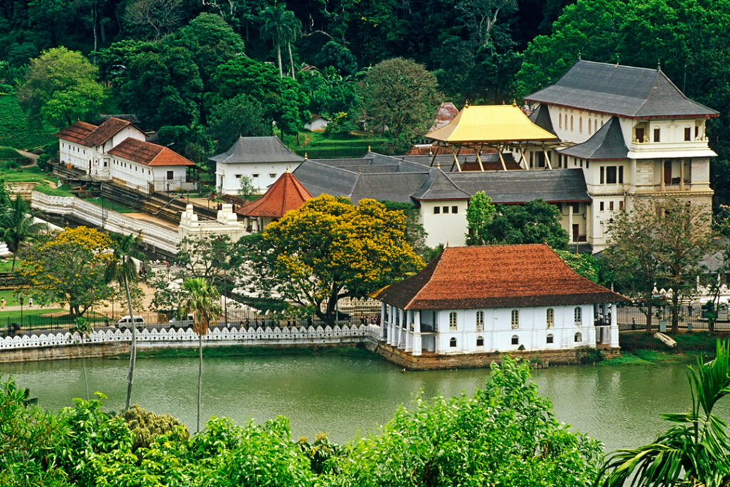
Temple of the Sacred Tooth Relic is a Buddhist temple in Kandy, Sri Lanka. It is located in the royal palace complex of the former Kingdom of Kandy, which houses the relic of the tooth of the Buddha. Since ancient times, the relic has played an important role in local politics because it is believed that whoever holds the relic holds the governance of the country. The relic was historically held by Sinhalese kings. The temple of the tooth is a World Heritage Site mainly due to the temple and the relic.
Bhikkhus of the two particular chapters, the Malwathu chapters and Asgiri chapters conduct daily worship in the inner chamber of the temple. Rituals are performed three times daily: at dawn, at noon, and in the evenings. On Wednesdays, there is a symbolic bathing of the relic with a herbal preparation made from scented water and fragrant flowers called Nanumura Mangallaya; this holy water is believed to contain healing powers and is distributed to those present.
10. Ella
Ella is a small town in the Badulla District of Uva Province , Sri Lanka governed by an UrbanCouncil. It is approximately 200 kilometres (120 mi) east of Colombo and is situated at anelevation of 1,041 metres (3,415 ft) above sea level. The area has a rich bio-diversity, densewith numerous varieties of flora and fauna. Ella is surrounded by hills covered with cloudforests and tea plantations. The town has a cooler climate than surrounding lowlands, due to its elevation. The Ella Gap allows views across the southern plains of Sri Lanka.
9. Temple of The Tooth Relic
Temple of the Sacred Tooth Relic is a Buddhist temple in Kandy, Sri Lanka. It is located in the royal palace complex of the former Kingdom of Kandy, which houses the relic of the tooth of the Buddha. Since ancient times, the relic has played an important role in local politics because it is believed that whoever holds the relic holds the governance of the country. The relic was historically held by Sinhalese kings. The temple of the tooth is a World Heritage Site mainly due to the temple and the relic.
Bhikkhus of the two particular chapters, the Malwathu chapters and Asgiri chapters conduct daily worship in the inner chamber of the temple. Rituals are performed three times daily: at dawn, at noon, and in the evenings. On Wednesdays, there is a symbolic bathing of the relic with a herbal preparation made from scented water and fragrant flowers called Nanumura Mangallaya; this holy water is believed to contain healing powers and is distributed to those present.
10. Ella
Ella is a small town in the Badulla District of Uva Province , Sri Lanka governed by an UrbanCouncil. It is approximately 200 kilometres (120 mi) east of Colombo and is situated at anelevation of 1,041 metres (3,415 ft) above sea level. The area has a rich bio-diversity, densewith numerous varieties of flora and fauna. Ella is surrounded by hills covered with cloudforests and tea plantations. The town has a cooler climate than surrounding lowlands, due to its elevation. The Ella Gap allows views across the southern plains of Sri Lanka.
11.Nuwara Eliya
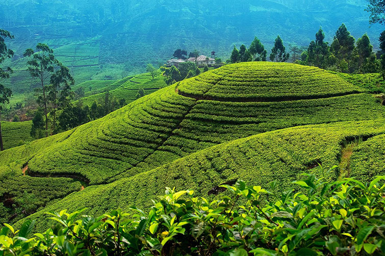
Nuwara Eliya is a city in the hill country of the Central Province, Sri Lanka. Its name means ‘city on the plain (table land)’ or ‘city of light’. The city is the administrative capital of Nuwara Eliya District , with a picturesque landscape and temperate climate. It is at an altitude of 1,868 m (6,128 ft) and is considered to be the most important location for tea production in Sri Lanka. The city is overlooked by Pidurutalagala , the tallest mountain in Sri Lanka. Nuwara Eliya is known for its temperate, cool climate – the coolest area in Sri Lanka.
12.Adam’s Peak
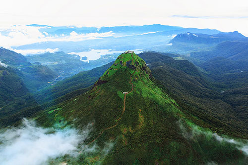
Adam’s Peak is a 2,243 m (7,359 ft) tall conical mountain located in central Sri Lanka. It is well known for the Sri Pada, ‘sacred footprint&’, a 1.8 m (5 ft 11 in) rock formation near the summit, which in Buddhist tradition is held to be the footprint of the Buddha, in Hindu tradition that of Hanuman or Shiva, ‘Mountain of Shiva’s Light’, and in some Islamic and Christian traditions that of Adam, or that of St. Thomas.
11.Nuwara Eliya
Nuwara Eliya is a city in the hill country of the Central Province, Sri Lanka. Its name means ‘city on the plain (table land)’ or ‘city of light’. The city is the administrative capital of Nuwara Eliya District , with a picturesque landscape and temperate climate. It is at an altitude of 1,868 m (6,128 ft) and is considered to be the most important location for tea production in Sri Lanka. The city is overlooked by Pidurutalagala , the tallest mountain in Sri Lanka. Nuwara Eliya is known for its temperate, cool climate – the coolest area in Sri Lanka.
12.Adam’s Peak
Adam’s Peak is a 2,243 m (7,359 ft) tall conical mountain located in central Sri Lanka. It is well known for the Sri Pada, ‘sacred footprint&’, a 1.8 m (5 ft 11 in) rock formation near the summit, which in Buddhist tradition is held to be the footprint of the Buddha, in Hindu tradition that of Hanuman or Shiva, ‘Mountain of Shiva’s Light’, and in some Islamic and Christian traditions that of Adam, or that of St. Thomas.
13.Whale Watching @ Mirissa
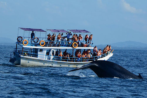
Mirissa is a small town on the south coast of Sri Lanka, located in the Matara District of the Southern Province. It is approximately 150 kilometres (93 mi) south of Colombo and is situated at an elevation of 4 metres (13 ft) above sea level. Mirissa’s beach and nightlife make it a popular tourist destination. It is also a fishing port and one of the island’s main whale and dolphin watching locations.
14.Bentota
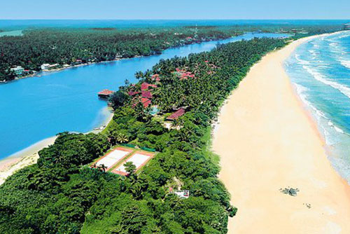
Bentota is a coastal town in Sri Lanka, located in the Galle District of the Southern Province. It is approximately 65 kilometres (40 mi) south of Colombo and 56 kilometres (35 mi) north of Galle. Bentota is situated on the southern bank of the Bentota River mouth, at an elevation of 3 metres (9.8 ft) above the sea level. The name of the town is derived from a mythical story which claims a demon named ‘Bem’ ruled the tota or river bank.
13.Whale Watching @ Mirissa
Mirissa is a small town on the south coast of Sri Lanka, located in the Matara District of the Southern Province. It is approximately 150 kilometres (93 mi) south of Colombo and is situated at an elevation of 4 metres (13 ft) above sea level. Mirissa’s beach and nightlife make it a popular tourist destination. It is also a fishing port and one of the island’s main whale and dolphin watching locations.
14.Bentota
Bentota is a coastal town in Sri Lanka, located in the Galle District of the Southern Province. It is approximately 65 kilometres (40 mi) south of Colombo and 56 kilometres (35 mi) north of Galle. Bentota is situated on the southern bank of the Bentota River mouth, at an elevation of 3 metres (9.8 ft) above the sea level. The name of the town is derived from a mythical story which claims a demon named ‘Bem’ ruled the tota or river bank.
15.Surfing @ Arugam Bay
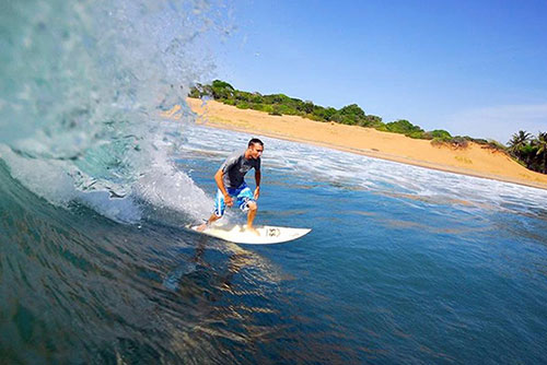
Arugam Bay known locally as ‘Arugam Kudah’ is situated on the Indian Ocean in the dry zone of Sri Lanka’s southeast coast, and a historic settlement of the ancient Batticaloa Territory (Mattakallappu Desam). The bay is located 117 kilometres (73 mi) south of Batticaloa , 320 kilometres (200 mi) due east of Colombo, and approximately 4 kilometres (2.5 mi) south of the market town of Pottuvil. The main settlement in the area, known locally as Ullae, is predominantly Muslim,[1] however there is a significant Sri Lankan Tamil and Sinhala population to the south of the village, as well as a number of international expatriates, largely from Europe and Australia. While traditionally fishing has dominated the local economy, tourism has grown rapidly in the area in recent years. Arugam Kudah’s literal Tamil translation is ‘Bay of Cynodon dactylon’. Tourism in Arugam Bay is dominated by surf tourism, thanks to several quality breaks in the area, however tourists are also attracted by the local beaches, lagoons, historic temples and the nearby Kumana National Park .
15.Surfing @ Arugam Bay
Arugam Bay known locally as ‘Arugam Kudah’ is situated on the Indian Ocean in the dry zone of Sri Lanka’s southeast coast, and a historic settlement of the ancient Batticaloa Territory (Mattakallappu Desam). The bay is located 117 kilometres (73 mi) south of Batticaloa , 320 kilometres (200 mi) due east of Colombo, and approximately 4 kilometres (2.5 mi) south of the market town of Pottuvil. The main settlement in the area, known locally as Ullae, is predominantly Muslim,[1] however there is a significant Sri Lankan Tamil and Sinhala population to the south of the village, as well as a number of international expatriates, largely from Europe and Australia. While traditionally fishing has dominated the local economy, tourism has grown rapidly in the area in recent years. Arugam Kudah’s literal Tamil translation is ‘Bay of Cynodon dactylon’. Tourism in Arugam Bay is dominated by surf tourism, thanks to several quality breaks in the area, however tourists are also attracted by the local beaches, lagoons, historic temples and the nearby Kumana National Park .